Clouds from two directions triggered two rounds of showers in Calcutta on Thursday, in the afternoon and evening.
Around 6.20pm, the Met office issued a red warning for a squall in Calcutta. The wind speed was expected to reach over 60kmph, the alert said, advising people to “stay in a safe place”.
Between 7pm and 9pm, the city received some rain and the conditions were consistently breezy. But the city was spared the fury of the winds. “Pockets of Howrah and Hooghly have witnessed strong gusts. But the clouds that came to Calcutta had weakened somewhat,” said a Met official.
The clouds that caused the showers in the evening had come from Jharkhand, via Jhargram, West Midnapore, East Burdwan, Howrah and Hooghly.
The volume of rain was much more in the afternoon, when the clouds had come from South 24-Parganas, he said.
Between 8.30am and 8.30pm, the Met office recorded around 61mm of rain in Alipore. In Met parlance, 60mm in 24 hours qualifies as heavy.
This was the second day of heavy rain that the ongoing wet spell has brought, after the one on Monday.
“On Thursday, the afternoon rain was mainly caused by clouds from South 24-Parganas, not far from Calcutta. The rain was uniform and widespread. In the evening, the clouds came mostly from Jharkhand. A squall was expected. But the clouds lost some steam en route,” said H.R. Biswas, head of the weather section at the Regional Meteorological Centre, Calcutta.
More rain is expected on Friday and Saturday, according to the forecast.
A trough connecting Assam and Odisha, and running over Gangetic Bengal, is the catalyst behind the overcast conditions, Biswas said.
“Under the influence of the trough and heavy moisture incursion from the Bay of Bengal, the rainy spell is likely to last for at least two more days,” he said.
On Thursday, the first round of showers started as a drizzle around 12.45pm. The intensity went up gradually and around 1.15pm, the rain had blurred visibility in many parts of the city. A hailstorm was reported from some pockets in and around the city.
In the afternoon spell, the Met office recorded around 32mm of rain in Alipore. It was mainly between 1pm and 3pm. In the same period, Ballygunge got around 75mm of rain, according to the figures obtained from the pumping stations of the Kolkata Municipal Corporation.
Parts of EM Bypass, near Dhapa, and Mominpore got around 65mm, the civic body said.
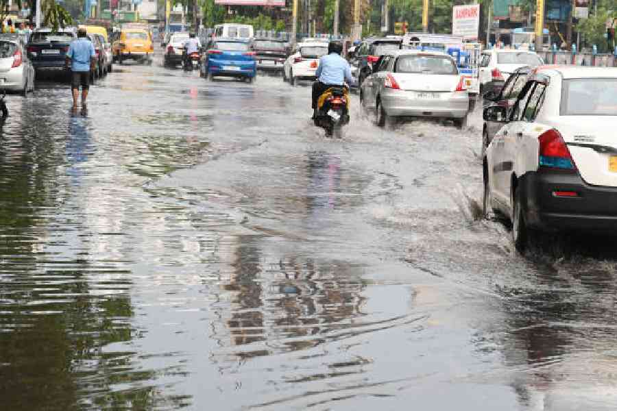
The showers had led to waterlogging on some busy roads and traffic had slowed considerably.
Camac Street, Central Avenue, Gariahat Road and Diamond Harbour Road were among the thoroughfares which were waterlogged, said an officer of the traffic department.
The south-bound flank of EM Bypass, near Captain Bheri, was also waterlogged.
“The load of vehicular traffic was relatively lighter in the afternoon. Otherwise, the problem would have aggravated,” the officer said.
Several Calcuttans said they saw a hailstorm after a long time. Pictures flooded social media.
A Met official said the hailstorm was reported only from some pockets of south Calcutta.
“The formation of hail is linked to the larger-than-usual volume of thunderclouds that, in places, touches the freezing troposphere. Parts of the city where the cloud columns touched the troposphere experienced frozen raindrops. It was localised and mainly reported from some parts of Jadavpur and Tollygunge and nearby areas,” said the Met official.