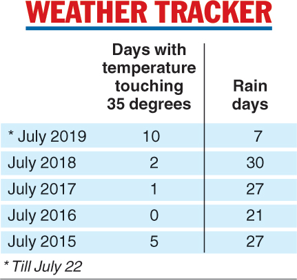
The Celsius clocked 35 degrees on 10 days this month, making it the hottest July in Calcutta in at least five years.
The average maximum July temperature in Calcutta is 32.4 degrees, a Met official said. With showers staying away, the maximum has remained below 33 degrees only on five days this month.
The average maximum temperature so far this month has been 34.7 degrees. The maximum temperature on Monday was 35.7 degrees, four notches above normal.
“With eight days still to go, the number of days with the maximum temperature above 35 would go up,” a Met department official said.
In contrast, there were only two such days in 2018, one in 2017, none in 2016 and five in 2015 (see chart).
Since July 12, the Celsius has shot past 35 degrees every day, barring July 20 when it settled at 34.9 degrees. On July 15, the Celsius clocked 37.7 degrees, the hottest July day in the city in at least a decade.
The high moisture content in the air has only worsened the torment.
Lower than the usual number of rain days — the days when the Alipore Met office records rainfall beyond traces — is the main reason for the rise in temperature, the Met department official said.
There have so far been only seven rain days in July — the rainiest month in Bengal. July 2018 had 30 rain days and July 2017, 27.
The absence of rain-triggering systems over the Bay of Bengal has been the bane for the monsoon in south Bengal this year.
“The absence of a cyclonic circulation over the Bay of Bengal meant the monsoon trough hardly passed over south Bengal this month. The trough had remained stationed over the foothills of the Himalayas for a fairly long period,” said Sanjib Bandyopadhyay, deputy director-general, India Meteorological Department, Calcutta.
The trough has been causing downpours in north Bengal since the second week of July. A weak cyclonic circulation over the east-central Bay of Bengal on July 17 had helped the trough descend, triggering hopes of rain in the southern districts of the state.
But the system was not strong enough and was pulled past south Bengal by an even stronger cyclonic circulation over Odisha, leading to rain in the neighbouring state.
The trough started climbing up again on Monday and went past Gorakhpur, Muzaffarpur and Cooch Behar and was moving towards Nagaland, the Met office said.
Under its impact, north Bengal is set to get heavy rain over the next two days.
“The monsoon trough keeps oscillating. When it is over the foothills of the Himalayas, north Bengal and the Northeast get rain. When it descends to the northern Bay of Bengal, coastal Bengal gets rain. If the trough descends further, peninsular India gets drenched. But it is unusual for the trough to skip south Bengal for such a long period,” Bandyopadhyay said.
The cumulative rain deficit (since June 1) for Calcutta stood at 65 per cent on Sunday, the Met office said.
The next two days in Calcutta are set to be hot and humid. There are chances of occasional thunderstorms and rain caused by some local formation.
“A cyclonic circulation may develop over the Bay of Bengal from July 26. If that happens, the monsoon trough will come down again and trigger rain in south Bengal,” a Met official said.