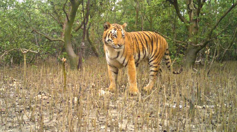
Technology is being used for the first time in the Sunderbans to have a sense of what life is like inside the depth of the mangroves.
Over 20,000 pictures and data on distribution, density and prey base have been sent from the Sunderbans to the Dehradun-based Wildlife Institute of India for the ongoing national tiger census, helmed by the National Tiger Conservation Authority.
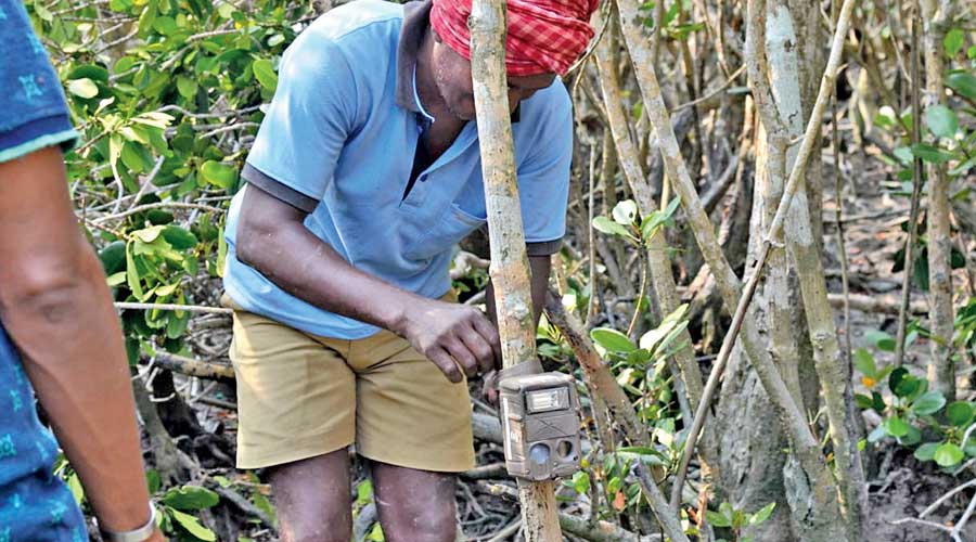
MSTrIPES (Monitoring System for Tigers: Intensive Protection and Ecological Status), a software-based tool, was used in the Sunderbans tiger count for the first time in the latest census.
The tool clicked tiger pictures and collected a host of other information — from the geographical coordinates to human-interference in the area.
It is embedded in trap cameras — placed in the mangrove forests from December last year to February — and phones of foresters and scientists steering the census.
The unique challenges posed by the terrain of the world’s only mangrove tiger habitat had prevented the use of the software. But after modifications, the system was finally fit for use in the Sunderbans, said wildlife biologists and foresters.
Earlier, a picture of a tiger was clicked at a particular spot. While that picture was loaded into the data pool, the geographical coordinates and a host of other information, like pugmarks and scat signs in the area, would have to be collected separately and fed into the system manually.
“Now, a single app collates all data that was earlier taken from multiple sources,” said Qamar Qureshi, a senior scientist with WII.
The system was suited for land-based surveys. It could not be used for the Sunderbans because any survey in the mangroves had to be done from boats.
Data from approximately 4 lakh square km of forested area across the country will be analysed for the census, the report of which is expected to be tabled next year.
The Sunderbans is spread across 10,000 sq km, a little above 4,000 sq km of which is in India. The rest is in Bangladesh. The Indian Sunderbans is split between the tiger reserve and the South 24-Parganas division.
“Out of the total (pan-India) area, roughly 40 per cent was covered by trap cameras. For the remaining area, we have information on vegetation, herbivore prey base, other carnivores, habitat quality (human interference), scat samples and so on,” said Qureshi.
The last national census in 2018 had a pool of roughly 3.5 crore pictures, of which, around 70,000 were tiger pictures, said Qureshi.
The census had counted 88 tigers in the Sunderbans. Twin successive state surveys — in 2019-20 and 2020-21 — had counted 96 tigers each.
Foresters said cyclones Amphan (2020) and Yaas (2021), which caused massive damage in the Sunderbans, had failed to dislodge the top predator from its terrain.
The MSTrIPES programme uses Global Positioning System (GPS), General Packet Radio Services (GPRS) and remote sensing to collect information from the field and create a database using IT-based tools. It also analyses the database using statistical tools.
It will give information on the herbivore population in the mangroves and human interference in a tiger habitat.
The pandemic forced many local people to turn towards the forests for livelihood, triggering a surge in human-wildlife conflicts.
Several people, in their bid to catch fish and crab, have lost their lives in tiger attacks in the past two years.
Last winter, there had been a series of tiger-straying incidents into the fringe villages, because residents breached nets to enter the forests.
The forest department has been releasing the captured stray tigers to forest pockets with lower tiger density.
“We have sent the information. The final report will cover much more than the tiger count. It will suggest the future roadmap,” said Tapas Das, field director of the Sunderbans Tiger Reserve.