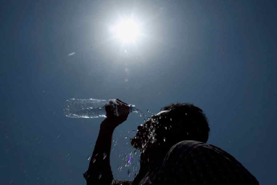
Around 1pm on Tuesday, a woman was boarding a Gariahat-bound minibus at Esplanade. Not an inch of her face was uncovered.
She was not alone. People mostly stayed indoors. If forced out in the afternoon, they had to take protection from the unyielding sun.
On Monday, the Met office issued a heatwave alert for the western districts of Bengal. Kolkata and neighbouring areas will be reeling from hot and uncomfortable weather till April 5, it said.
A heatwave is declared when the mercury breaches the 40-degree mark and the maximum is five notches above normal. The maximum temperature did not touch 40 degrees in Bengal on Tuesday.
But the Met office issued another bulletin saying “heatwave conditions” are likely in Purulia, West Burdwan, West Midnapore, Birbhum, Bankura and Jhargram between April 2 and 6.
“Even without a heatwave, the conditions will be very hot,” said a Met official.
Q: How hot is it?
A: The Met office recorded a maximum temperature of 36.7 degrees Celsius in Alipore on Tuesday. It was two notches above normal. Salt Lake was marginally hotter at 37.3 degrees. Bankura and Panagarh (West Burdwan) sizzled at 39.5 degrees each. Suri in Birbhum saw the Celsius rise to 39 degrees. Several other places in the western districts recorded a maximum temperature ranging between 38 and 39 degrees.
Q: What is the forecast?
A: Hotter days. In the western districts, the Celsius is expected to go up by “four to five” degrees between April 3 and 6. In the remaining parts of south Bengal, including Kolkata, the Celsius is likely to climb by “two to three degrees”. In short, there is no immediate relief from the assault.
Q: Why is it so hot?
A: Because there is less sweating, said Met officials. On Tuesday, the minimum relative humidity was 30 per cent. For a major part of the day, the moisture content in the atmosphere was around 40-45 per cent. Humidity causes a lot of sweating, often making the day unbearable. But the same humidity makes the conditions ideal for thunderstorms in the evening. “In south Bengal, moisture comes from the Bay of Bengal. Moist winds from the Bay are missing. Hot and dry westerly winds are having a free run in south Bengal via the northern plains,” said Somenath Dutta, deputy director-general, IMD, Kolkata.
Q: Where has the moisture gone?
A: To the Northeast, said a Met official in Delhi. “Southwesterly winds from the Bay, blowing at around 40kmph and at a height of 1km from the surface, are almost entirely going to the Northeast via Bangladesh and Tripura. These are moist winds, triggering widespread rain in Tripura, Assam, Meghalaya, Mizoram, Manipur and Arunachal Pradesh and neighbouring states,” the official told The Telegraph.
An anticyclone is now over central and east-central Bay. The position is such that the moisture outflow is towards the Northeast. There is a convergence of winds from two directions — northwest and southwest — over east Assam and neighbouring areas. The convergence is leading to the creation of rain-bearing clouds.
A cyclonic circulation over Bangladesh has briefly stalled the flow of the northwesterly winds to the Northeast. “But the system is expected to weaken considerably by Wednesday, paving the way for the convergence again,” said the Met official in Delhi.
The IMD forecast from Delhi said: “Fairly widespread to widespread light/moderate rainfall/snowfall with isolated thunderstorms & lightning very likely over Arunachal Pradesh; scattered to fairly widespread light to moderate rainfall over Assam & Meghalaya and Nagaland, Manipur, Mizoram & Tripura during 2nd-07th April, 2024.”
Q: When will moisture start entering south Bengal again?
A: When the anticyclone shifts back towards the north Bay, which is closer to the Bengal coast. A seasonal trough, which is weak now, is also expected to strengthen and make the conditions ideal for the incursion of moisture into south Bengal. “But that is likely to start happening after at least three to four days,” said the Met official.